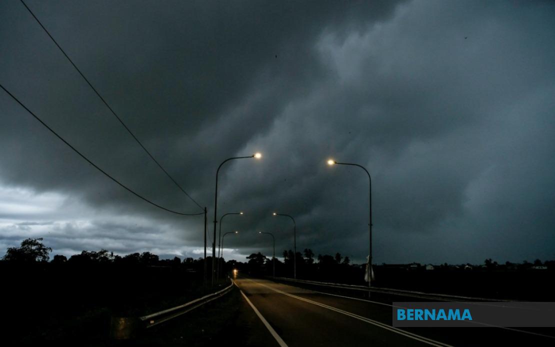
The Malaysian Meteorological Department has activated a wide-ranging weather advisory covering thunderstorms, torrential rain and strong winds that will persist until 9 pm today, affecting communities across nine states and the federal territory of Labuan. The alert represents a significant weather system impacting both Peninsular Malaysia and Sarawak and Sabah in East Malaysia, requiring residents and motorists in these regions to exercise heightened caution during the afternoon and early evening hours.
Perlis faces the broadest risk under the warning, with the entire state positioned within the affected zone. In Kedah, the threat concentrates in specific districts including the island of Langkawi alongside mainland areas such as Kubang Pasu, Kota Setar, Pokok Sena, Padang Terap, Sik and Baling. Perak's vulnerable areas span the northern stretches at Kerian, Larut, Matang and Selama, extending southward to encompass Kuala Kangsar and the central regions of Kinta and Kampar, creating a continuous band of exposure across the state's length.
In the east coast and central territories, Pahang experiences significant risk in its highland and interior districts, particularly Cameron Highlands where elevation can intensify weather patterns, alongside lowland zones including Bentong, Bera and Rompin. Selangor's exposure is concentrated in the eastern region of Hulu Langat, which borders Pahang's highlands and frequently experiences orographic rainfall enhancement. Negeri Sembilan faces similar conditions in its southern districts of Jelebu and Jempol, while Johor's southeastern reaches including Segamat, Kluang and the coastal area of Mersing remain under alert, indicating how the system extends far down the peninsula.
Sarawak experiences the most geographically dispersed warnings among Malaysian states. The southwestern corner centered on Kuching and its satellite district of Bau faces immediate risk, while the southern divisions of Serian and Samarahan—encompassing both Samarahan proper and Asajaya—form another vulnerable corridor. Moving northeastward, the mid-coast districts including Sarikei's Meradong area, Sibu, and Mukah's Tanjung Manis all fall within the alert zone. The interior divisions of Kapit, encompassing both Song and Kapit town, alongside the northern coastal belt of Bintulu stretching to Tatau and Sebauh, extend the warning across the state's vast interior. Miri's mountainous hinterland at Marudi and the northeastern division of Limbang complete Sarawak's exposure.
Sabah's warning encompasses diverse geographic zones, from the northwestern interior dominated by the interior plateau containing Sipitang, Kuala Penyu, Beaufort and Tambunan, to the developed west coast urban and rural areas, and the eastern divisions of Sandakan encompassing Tongod and the sprawling Kinabatangan district. This combination suggests the system has sufficient atmospheric moisture and uplift mechanisms to affect both coastal and mountainous terrain across the state.
Thunderstorms of this geographic and temporal scope typically indicate the presence of a convergence zone or significant mesoscale circulation feature, rather than isolated afternoon convection. The persistence of warnings into the evening suggests the system possesses organizational structure that will maintain intensity through the typical diurnal warming cycle. For residents, the combination of heavy rainfall, lightning activity and strong gusts poses multiple hazards—flooding in low-lying areas and near waterways, fallen tree branches and power disruptions, plus the standard risks associated with reduced visibility and slippery road surfaces.
The breadth of this warning underscores how rapidly atmospheric conditions can deteriorate during Malaysia's monsoon transition periods. The concentration of alerts in northern Peninsular Malaysia and across East Malaysian territories suggests moisture convergence patterns typical of regional wind shifts. Travelers in affected zones should monitor weather updates continuously, avoid driving through flooded areas, seek shelter away from windows and avoid outdoor activities near large trees. Airlines and ferry services may experience disruptions given the thunderstorm warning extends through the critical evening departure window.
Authorities in these regions would typically activate precautionary measures including monitoring of drainage systems, positioning of emergency response teams near flood-prone areas, and alerts to construction sites where overhead work poses additional risk during severe conditions. The specificity with which MetMalaysia identifies affected districts enables local authorities and residents to focus preparations on likely impact zones rather than overestimating risk across entire states. Businesses and schools in the identified areas may also adjust operating hours to ensure personnel safety during the warning period.