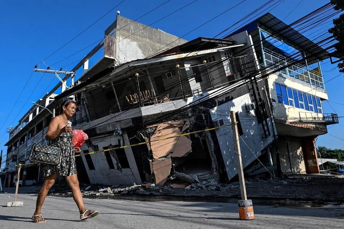
The June 8 earthquake that struck the southern Philippines with a magnitude of 7.8 has left an indelible mark not just on the communities it devastated, but quite literally on the landscape itself. When Arsenio Butil Jr., a fisherman and pastor in Glan, Sarangani province, emerged from his home after the initial tremor subsided, he witnessed something few people experience in their lifetimes: the shoreline of his home undergoing dramatic transformation before his very eyes. Where the sea had once stretched to the water's edge, vast expanses of previously submerged coral now lay exposed to the air, their bleached surfaces visible for kilometres along what was once a familiar coast.
The earthquake, which killed at least 76 people across Mindanao, derived its destructive power from tectonic forces operating along the nearby Cotabato Trench, a zone of intense seismic activity roughly 50 kilometres offshore. The shifting of massive rock formations at depth triggered not only the violent shaking that toppled buildings and triggered devastating landslides, but also a phenomenon that geoscientists call coastal uplift. In this case, the earth's crust rose substantially along a stretch of coast, with the seabed lifting by approximately two metres according to initial assessments by the Philippines' seismology centre. The practical effect has been to extend the shoreline by as much as 200 metres in some locations, with affected communities spread across nearly 100 kilometres of coast.
Butil Jr. described the immediate aftermath with vivid clarity, recounting how the water behaved in ways that would have seemed impossible to most observers. He watched as the sea retreated from the shore, then gradually returned, only to recede again in a cycle repeated several times. This oscillation, though alarming to witness, was the visible expression of immense geological forces redistributing the earth's crust. Fish, disoriented and dying from the changed conditions, floated on surfaces where they had swum moments before. For a man who has spent his entire life on this coast, the transformation was both terrifying and unfamiliar. This was, he emphasised, the largest earthquake he had ever experienced.
The Cotabato Trench has long been a focal point of seismic concern for geologists monitoring the Philippines. In January, the region experienced a swarm of thousands of small tremors, a phenomenon that caught the attention of UN disaster risk reduction specialists. A report released in mid-May suggested these tremors could presage a significant seismic event, a prediction that proved disturbingly accurate. The trench sits at the intersection of major tectonic plates, making it one of the most active seismic zones in Southeast Asia. For those living and working along Mindanao's southern coast, this geological reality translates into constant underlying risk, with events of the magnitude experienced in June serving as brutal reminders of the forces constantly working beneath their feet.
Nane Danlag, speaking from her office at the Philippines' seismology centre in General Santos City, explained that the changes residents were observing represented a permanent alteration to their geography. The newly elevated coastline would not recede; the seabed would not sink back to its previous level. As startling as this transformation appeared to those living through it, Danlag emphasised that such movements were not aberrations but rather part of a continuous geological process that has been reshaping these islands for millennia. The tectonic forces at work operate on timescales that dwarf human experience, yet their effects, when concentrated into a single violent moment, become immediately and viscerally apparent.
The human consequences of this geological shift have been profound and multifaceted. More than 100 residents of a neighbouring village, predominantly fishermen and their families, remain encamped on higher ground, having fled there when the earthquake struck. Datu Atom Malimpnig, a Maguindanaon chieftain representing these displaced communities, articulated the deep-seated anxiety that keeps people from returning to their destroyed homes. The elevated seabed, while scientifically explained as a natural phenomenon, has become in the minds of these residents a harbinger of potential tsunami danger. The fear that the sea might surge forward with devastating force keeps families huddled on hillsides where they feel safer, even as government workers distribute rice porridge and basic supplies.
Beyond the humanitarian crisis facing fishing communities lies another dimension of the disaster: its impact on tourism and economic activity. Edzel Baylon, a staff member at the Isla Jardin del Mar resort, confronted a different kind of catastrophe as she surveyed the transformed landscape surrounding her workplace. The resort's principal attraction had always been its white sand beaches and crystal waters, marketed as an idyllic tropical escape. Now, a wall of jagged, dead coral separated the beach from navigable water, rendering the shoreline unrecognisable and unsuitable for swimming. What was once a key selling point had become an obstacle, a stark visual reminder of the earthquake's reach into economic livelihoods far beyond those directly injured or killed by the initial tremor.
The seismic activity in the region has shown no signs of abating. Since the initial June 8 earthquake, the Philippine seismology agency has recorded more than 8,500 aftershocks, a continuing pattern of seismic unrest that extends the period of danger and anxiety indefinitely. These aftershocks, though typically much smaller than the main event, nonetheless serve as constant reminders of the instability that pervades the region. They also pose a specific hazard to partially damaged structures and to residents attempting to return home and assess damage to their properties. Butil Jr. observed that the ground surrounding his community remains fractured, with long cracks visible in the earth. The possibility that another major earthquake could strike, compounding the damage already inflicted, weighs heavily on the minds of those contemplating reconstruction.
The broader implications of this event extend across the entire Southeast Asian region, which sits atop some of the world's most active tectonic zones. The Philippines, straddling the Pacific Ring of Fire, experiences frequent seismic activity that ranges from inconsequential tremors to occasionally catastrophic earthquakes. This June event has once again highlighted the vulnerability of coastal communities throughout the region to sudden geological upheaval. For Malaysia, which has its own seismic zones particularly in Sabah and Sarawak, the Mindanao earthquake serves as a cautionary reminder of the importance of earthquake preparedness, building codes designed to withstand seismic stress, and early warning systems that can provide precious seconds or minutes for residents to take protective action.
Reconstruction efforts face daunting challenges beyond the immediate need to clear rubble and tend to injured survivors. Communities must now grapple with the reality of permanently changed geography, the psychological trauma of witnessing landscape transformation on a massive scale, and the uncertainty of continued seismic activity. Butil Jr. and others in Glan are not yet prepared to rebuild, waiting instead to see whether the region stabilises or whether additional major earthquakes might strike. The newly exposed seabed, while scientifically fascinating as an example of active tectonic processes, represents to residents the loss of everything familiar, the destruction of livelihoods dependent on coastal access, and an uncertain future in a landscape that has become hostile and unpredictable. As the region continues to experience frequent aftershocks, normalcy remains a distant prospect.


%22%2F%3E%3C%2Fpattern%3E%3C%2Fdefs%3E%3Crect%20width%3D%22100%25%22%20height%3D%22100%25%22%20fill%3D%22url(%23ph4w4yvg)%22%2F%3E%3Crect%20width%3D%22100%25%22%20height%3D%22100%25%22%20fill%3D%22url(%23ph4w4yvp)%22%2F%3E%3Ctext%20x%3D%2250%25%22%20y%3D%2250%25%22%20text-anchor%3D%22middle%22%20dominant-baseline%3D%22central%22%20fill%3D%22rgba(255%2C255%2C255%2C0.95)%22%20font-family%3D%22Georgia%2C%20'Times%20New%20Roman'%2C%20serif%22%20font-weight%3D%22700%22%20font-size%3D%22226%22%20letter-spacing%3D%22-0.02em%22%3EPenang%3C%2Ftext%3E%3C%2Fsvg%3E)