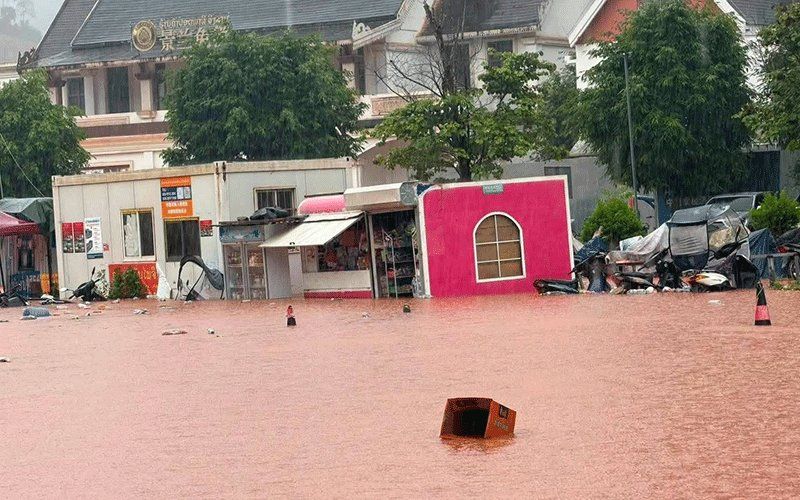
Luang Namtha province in northern Laos has been officially declared a disaster zone following catastrophic flooding that swept through the Boten border area with China on Saturday, August 29. The Luang Namtha Provincial Administrative Committee issued the declaration after widespread inundation damaged buildings, infrastructure, farmland and a special economic zone across more than 30 affected villages. The flooding and associated landslides struck the Luang Namtha and Nalae districts with particular force, submerging structures near waterways, damaging an airport facility, schools, hospitals and vast tracts of agricultural land in what represents a significant blow to the provincial economy and local livelihoods.
Despite the severity of the flooding around the border crossing, the Boten checkpoint itself—one of the region's key commercial arteries linking Laos and China—remained operational and unaffected by the disaster. This distinction is significant for cross-border trade and regional connectivity, as the crossing continues to facilitate important economic interchange between the two nations. However, the surrounding landscape and civilian infrastructure bore the brunt of nature's assault, with entire communities left struggling in the aftermath.
The immediate trigger for this disaster was a rapid swelling of upstream river systems after several days of relentless rainfall in the region. Heavy precipitation cascading from higher elevations sent torrents of water southward into Laos, overwhelming river systems designed for normal seasonal flow. Hydrology monitoring data painted a stark picture of the crisis: a measuring station on the Tha River recorded water levels reaching 6.58 metres on Saturday, surpassing the official 6-metre flood warning threshold and dangerously approaching the 7-metre critical flood level that would trigger even more severe consequences.
Responsee from the Laotian meteorological and hydrological authorities has been swift and comprehensive. The Department of Meteorology and Hydrology, operating under the Ministry of Agriculture and Environment, issued formal flood warnings for the Tha River covering August 29-30, alerting residents and local administrators to the ongoing threat. Provincial officials have mandated that administrative bodies across five districts implement immediate alert systems, notifying citizens in riverside settlements, depression-prone areas and other at-risk zones to prepare emergency evacuation plans should water levels continue their dangerous ascent.
The scale of the weather event extends well beyond Luang Namtha's borders. A broader meteorological warning encompasses 14 provinces across northern Laos bracing for impact this weekend as a low-pressure system moves southeastward from the border region. The combination of this atmospheric disturbance with the ongoing southwestern monsoon pattern is forecast to generate widespread scattered thunderstorms, moderate to heavy rainfall and gusty winds across the entire northern corridor. Provinces in the warning zone include Phongsaly, Huaphan, Luang Prabang, Luang Namtha, Oudomxay, Xaysomboun, Bolikhamxay, Khammuan, Savannakhet, Salavan, Xekong, Champasak, Attapeu and the capital region of Vientiane, demonstrating the geographic breadth of the weather system affecting the nation.
Local government authorities have implemented a layered system of crisis management to confront the flooding. Officials have been explicitly ordered to maintain continuous surveillance of hydrological conditions, respond with agility to emerging incidents and transmit regular situation reports up the chain of command to provincial leadership. This emphasis on real-time monitoring and communication reflects lessons learned from previous natural disasters in Southeast Asia, where delayed information flow has historically contributed to preventable casualties and compounded damage.
For Malaysia and other Southeast Asian nations, this Laotian disaster carries particular resonance as the region shares similar monsoon patterns and geographic vulnerabilities. The southwestern monsoon that is contributing to Laos's current crisis will, in coming weeks, influence rainfall patterns and river levels across Malaysia, Thailand and other regional neighbours. The incident underscores how climate variability and extreme weather are increasingly testing the infrastructure and preparedness systems of developing economies in the region, particularly those with significant populations living in flood-prone areas.
The broader implications of this disaster extend to regional cooperation frameworks. The Mekong River Commission and bilateral agreements between riparian nations become critical during such events, as upstream flooding in Laos inevitably affects downstream water management in Thailand, Cambodia and Vietnam. The cross-border nature of many river systems means that meteorological cooperation and coordinated response mechanisms are essential for mitigating cascading impacts across national boundaries.
For residents in the affected areas of Luang Namtha and beyond, the next 48 hours represent a critical window of vulnerability. Authorities have issued specific guidance for communities to remain vigilant, closely track meteorological forecasts and prepare contingency plans for sudden flash flooding and potential landslides on steep terrain. With harvest seasons often coinciding with monsoon periods, the economic toll on farming communities could be substantial, affecting food security and rural incomes across multiple provinces in northern Laos during the crucial post-flood recovery phase.

