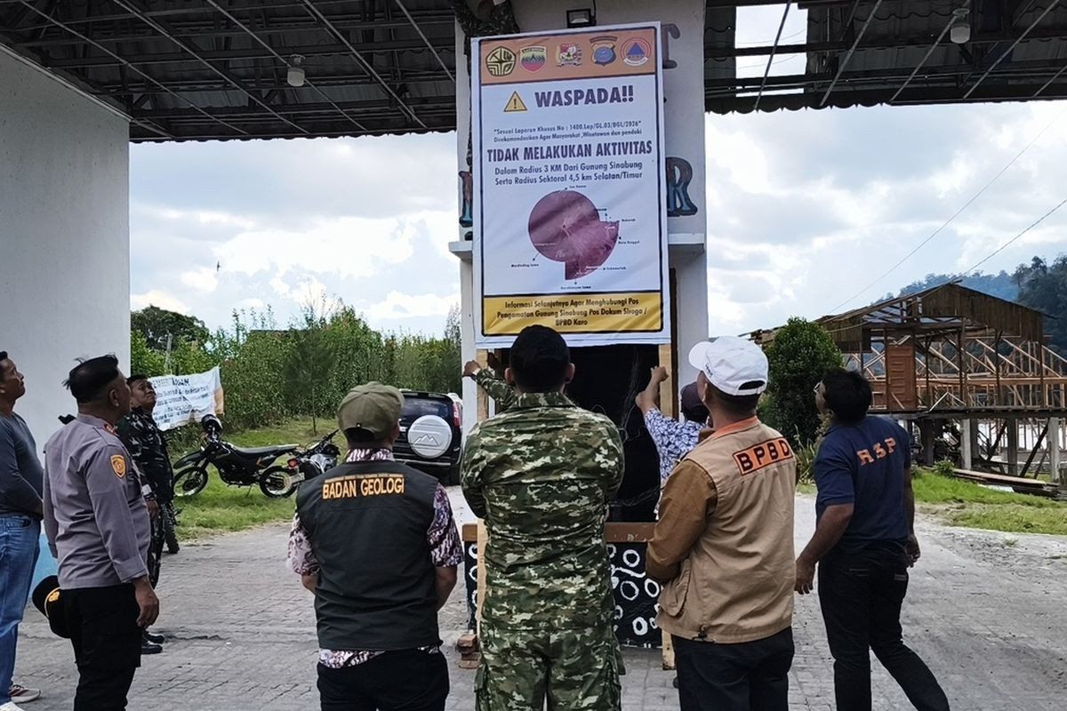
Indonesian authorities have shut down major tourism attractions in North Sumatra's Karo regency as Mount Sinabung shows mounting signs of restlessness. The Karo regional government has temporarily sealed Lau Kawar Lake and its adjacent camping facilities in Kuta Gugung village, effective from August 19, with no set reopening date. The decision follows recommendations from the Vulcanology and Geological Disaster Mitigation Center's dedicated monitoring command post and a public advisory issued by the Karo regent on August 14 that cautioned residents and visitors against approaching the volcano.
The volcanic alert system has been elevated from Level I Normal to Level II Waspada (advisory), reflecting genuine escalation in the mountain's behaviour over recent days. Officials have implemented exclusion zones around the summit—three kilometres as a standard safety radius, with an extended 4.5-kilometre perimeter extending toward the south-east sector. For residents living along waterways fed by mountain runoff, authorities have emphasized heightened vigilance regarding potential mudflow hazards, a characteristic danger accompanying increased volcanic unrest in such terrain.
The intensity of seismic activity has become a principal concern for monitoring teams. Early Thursday morning recorded five volcanic earthquakes within Mount Sinabung itself, accompanied by additional tectonic tremors. This marked a notable increase compared to Wednesday's reading, which had registered just one volcanic earthquake alongside seven tectonic events. Mount Sinabung's monitoring post head Armen Putra has articulated a direct correlation between heightened seismic frequency and eruption potential, implying that current patterns warrant serious attention. Visual observations have complemented the instrumental data, with thick smoke plumes billowing between 100 and 800 metres above the summit.
Malaysia and other Southeast Asian nations have historical reason to monitor Mount Sinabung closely, given the volcano's capacity to spread ash across regional boundaries. The 2,460-metre volcano entered an active phase following a roughly four-century dormancy, erupting for the first time on August 29, 2010. Though that initial eruption subsided by September, the volcano demonstrated its volatile nature through renewed activity in September 2013, escalating to a catastrophic phase by November 2013 when it reached the highest alert level IV Awas (warning).
The November 2013 eruption proved particularly destructive, generating lethal pyroclastic flows that killed dozens and displaced thousands from 21 villages and two hamlets. The volcano sustained elevated activity continuously until May 2019, when authorities downgraded the alert to Level III Siaga (watch) following instrumental analysis suggesting declining threat severity. However, this respite proved temporary. Mount Sinabung erupted again on July 28, 2021, ejecting ash columns reaching 4,500 metres and scattering pyroclastic material up to 1,000 metres eastward. That eruption, the most recent before the current unrest, affected at least five districts with substantial ash fallout, demonstrating the volcano's enduring capacity for significant regional impact after eleven years of prior continuous activity.
For Malaysian residents and regional observers, Mount Sinabung's periodic resurgence carries implications beyond Indonesia's borders. Volcanic ash from major Sumatran eruptions has historically drifted across the Strait of Malacca, affecting air quality in Peninsular Malaysia and creating visibility challenges for aviation and maritime operations. The 2021 eruption illustrated this pattern, with ash dispersion affecting multiple districts across north Sumatra. Current escalating activity therefore warrants monitoring not only by Indonesian authorities but by Malaysian environmental and disaster management agencies preparing contingency responses.
The closure of tourism infrastructure represents a precautionary but necessary step. Lau Kawar Lake and associated camping grounds have attracted domestic and international visitors seeking nature-based recreation in the region. The indefinite shutdown reflects official recognition that volcanic hazards cannot be predicted with sufficient precision to permit safe recreational activity in proximate areas. Tourism operators and hospitality providers in the broader Karo region face economic disruption, though public safety remains the paramount consideration.
Authorities have deliberately communicated the basis for these restrictions, citing both recent monitoring data and formal recommendations from specialized vulcanological institutions. Such transparency helps build public and visitor compliance with safety directives. The Karo Youth Affairs, Sports and Tourism Agency's public statements have emphasized that closures constitute anticipatory measures rather than responses to imminent eruption, distinguishing between elevated risk and immediate catastrophic threat. This calibrated messaging aims to prevent both complacency and panic.
The volcano's historical pattern reveals unpredictable intervals between major eruptions and activity phases. Its dormancy spanning approximately four centuries before 2010 underscores the difficulty in predicting long-term volcanic behaviour. More recent cycles—the 2010 eruption, the 2013 escalation, the 2019 downgrade, and the 2021 renewed activity—suggest Mount Sinabung operates on shorter timescales of unrest and relative quiescence. Current indicators place it within a concerning trajectory that historical precedent suggests could intensify further.
Regional disaster preparedness frameworks, which Malaysia participates in through ASEAN structures, benefit from detailed monitoring and transparent communication about volcanic hazards in Indonesia. Mount Sinabung's behaviour influences broader Southeast Asian emergency response protocols, particularly regarding transboundary ash dispersion and air quality management. The current closure and alert elevation represent proactive governance that reflects lessons learned from prior eruptions and improved scientific understanding of warning signs.
Tourists and adventure enthusiasts must now seek alternative destinations while Karo regency implements these precautionary measures. Regional authorities maintain continuous real-time monitoring through instrumental networks and trained observation teams, enabling rapid alert adjustments should conditions either stabilize or deteriorate. The temporary nature of the closure underscores that officials anticipate potential normalization, though no timeline has been announced. Meantime, the volcano's elevated activity serves as a reminder of the dynamic geological forces shaping Indonesia's landscape and the ongoing preparedness required across the region.

