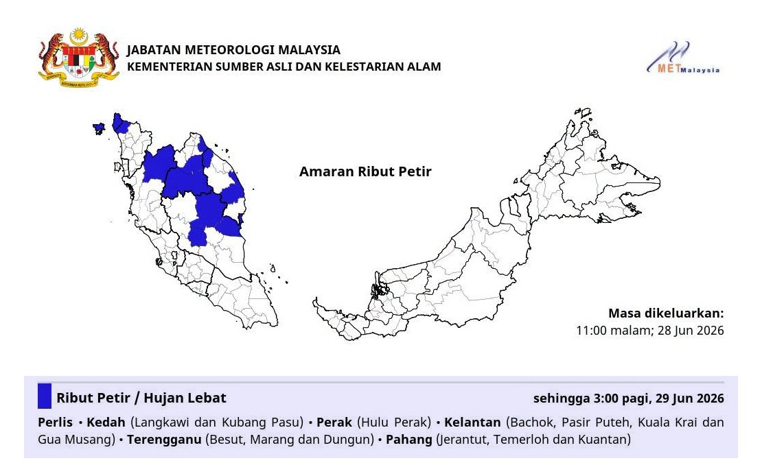
The Malaysian Meteorological Department (MetMalaysia) has activated a severe weather alert covering six states across the country's northern and eastern regions, with conditions expected to persist through the early morning hours until 3am. The alert encompasses a significant swath of Peninsular Malaysia, reflecting an active weather system moving across the region that residents and authorities should monitor closely during the night ahead.
Perlis stands as the northernmost state under the warning, with the adjacent state of Kedah facing heightened risk particularly in the Langkawi and Kubang Pasu districts. These northern coastal and lowland areas face exposure to thunderstorms accompanied by the potential for surface-level wind intensification, which could affect maritime activities and coastal communities. The maritime zones around Langkawi, a major tourism destination, warrant particular attention given the region's importance to both local economies and international visitors.
On the western side of the peninsula's upper tier, Perak's Hulu Perak district—mountainous terrain in the state's interior—has also been designated as a warning zone. This inland upland region, characterised by higher elevation, may experience particularly vigorous storm activity as atmospheric systems interact with topography. The combination of mountainous geography and heavy rainfall poses specific hazards for communities in remote and valley areas reliant on road networks that could be compromised by runoff and landslide risk.
Kelantan's involvement encompasses four specific zones: Bachok, Pasir Puteh, Kuala Krai and Gua Musang. This eastern seaboard state, already accustomed to seasonal monsoon influences, sees its central and northern districts flagged for immediate concern. The geographic spread across multiple zones within Kelantan indicates the breadth of the weather system rather than isolated local effects, suggesting a frontal passage or organised convective outbreak rather than scattered cell development.
Terengganu's coastal and central districts of Besut, Marang and Dungun complete the eastern seaboard coverage, placing three of the state's key settlement zones under alert. These areas along the South China Sea coast experience frequent weather volatility, but formalised warnings underscore conditions exceeding normal thresholds. Besut in the north and Dungun in the south bracket Terengganu's population distribution, indicating broad regional exposure to the weather system.
On Peninsular Malaysia's east coast, Pahang rounds out the six-state alert with three affected zones: Jerantut in the interior, and the major population centres of Temerloh and Kuantan. Kuantan, as Pahang's state capital and principal economic hub, commands particular attention given the potential disruption to urban services, transportation and commerce. Temerloh's position along the Pahang River introduces fluvial flooding considerations alongside direct rainfall threats.
The temporal window specified—through 3am—represents a critical overnight period when visibility decreases and emergency response capabilities face natural constraints. Residents, travellers and commercial operators across these six states should exercise heightened caution during night hours, with particular attention to weather updates from MetMalaysia. Motorists should consider whether travel is essential and adjust speeds accordingly, while those in flood-prone areas should remain vigilant regarding drainage and water accumulation.
The geographic distribution of this alert—spanning from Perlis in the north through the central east coast to Pahang in the south—suggests a significant weather system affecting a substantial portion of the northern and eastern peninsula. This is not merely scattered convective activity but an organised pattern warranting coordinated attention. For regional analysts, the warning reflects the operational sophistication of Malaysia's meteorological infrastructure in detecting and communicating weather threats with precision regarding both location and timing.
Emergency management authorities at state and district levels will likely activate standard severe weather protocols, pre-positioning resources and establishing communication channels. Residents should keep mobile devices charged, avoid unnecessary travel during the warning window, and ensure that household drainage systems remain clear. Agricultural activities, particularly in Kelantan and Terengganu, may experience temporary disruption, though the overnight timeframe limits field operations exposure.
The specificity of MetMalaysia's alert—naming individual districts rather than entire states—reflects modern meteorological precision and demonstrates the department's commitment to targeted public communication. This geographic granularity helps residents and authorities distinguish between immediate threats and peripheral areas, enabling more effective resource allocation and decision-making. For those in designated zones, the alert serves as actionable intelligence supporting personal safety measures throughout the night.