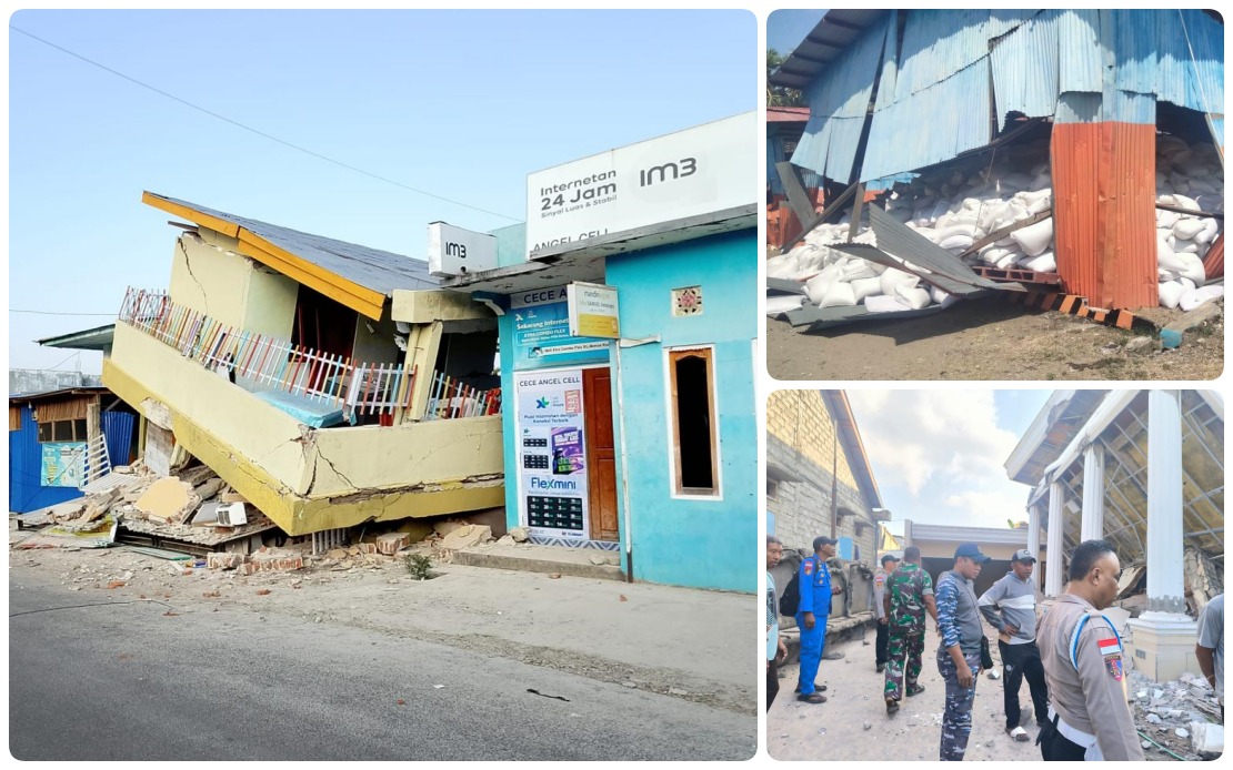
Indonesia's Flores Island faced the harrowing aftermath of a devastating magnitude 7.7 earthquake on Sunday, as authorities documented nearly 1,000 subsequent tremors and struggled to house thousands of displaced residents. The powerful seismic event, which struck at 4:58 am local time with its epicentre approximately 30 kilometres offshore from Mbay in Nagekeo district at a depth of 15 kilometres, has claimed at least 53 lives while injuring 135 others across seven affected administrative regions.
The Indonesian authorities moved swiftly to assess the full scope of the disaster. According to the National Disaster Management Agency (BNPB), by Sunday afternoon the Meteorology, Climatology and Geophysics Agency (BMKG) had catalogued 995 recorded aftershocks, though officials noted that only a fraction of these were perceptible to residents. Abdul Muhari, BNPB's Deputy for Prevention, told journalists during an online briefing that the agency had received no reports of missing persons across the affected areas, suggesting that initial search and rescue operations had been relatively comprehensive. The careful documentation of aftershocks reflects the scientific challenge Indonesia faces in monitoring seismic activity across its vast archipelago, which sits along the Pacific Ring of Fire and experiences frequent tectonic disturbances.
The psychological and practical dimensions of the disaster extend well beyond immediate casualty figures. Nearly 9,300 residents had sought refuge at evacuation centres by the end of Saturday, driven not only by fear of subsequent tremors but also by the scale of structural damage to homes and communities. Officials identified lingering trauma from the catastrophic 1992 Flores earthquake and tsunami as a significant factor keeping residents away from their damaged dwellings, even as authorities worked to secure the sites. This historical context proves crucial for understanding civilian behaviour during post-disaster operations, as communities that have endured previous seismic catastrophes often demonstrate heightened caution.
The initial earthquake triggered immediate alarm across maritime authorities, prompting the swift issuance of a tsunami warning that covered the surrounding waters. However, observations of sea-level movements showed no dangerous surge, and BMKG lifted the alert at 7:31 am after careful monitoring confirmed the absence of significant oceanic disturbance. The rapid assessment and cancellation of the tsunami warning reflected improved early-warning protocols that Indonesia has developed following the devastating 2004 Indian Ocean disaster, demonstrating how institutional learning shapes disaster response capabilities.
Emergency responders concentrated their efforts on three critical fronts during the crisis's opening phase. First, they mobilised search and rescue personnel and distributed food, water, shelter materials and medical supplies to evacuation centres and affected communities. Second, teams systematically assessed the extent of damage to residential and public infrastructure, a process essential for prioritising reconstruction efforts. Third, authorities worked methodically to restore critical infrastructure, including road access and electricity supply disrupted by the quake's impact.
Progress on infrastructure restoration began emerging within hours of the disaster. Officials reported that a major landslide affecting the road through Reok in Manggarai district—a critical transportation artery—had been cleared sufficiently to permit fuel tanker trucks to pass through, a development with significant implications for restocking emergency supplies. Electricity supplies returned to service in multiple earthquake-affected zones, easing the burden on displaced populations and supporting medical facilities treating the injured. Such incremental improvements in connectivity and utilities provide essential breathing room for overwhelmed relief systems.
To coordinate the massive relief operation, the BNPB established dedicated response command posts in the key logistical hubs of Labuan Bajo and Maumere, with additional support coordination centres activated in Jakarta to manage supply chains and personnel deployments. Equipment and personnel continued moving toward affected areas through activated logistics networks, while aircraft and helicopters maintained standby status to deploy reinforcements or supplies should ground-based operations prove insufficient. This layered approach to disaster management reflects Indonesia's experience managing emergencies across its geographically dispersed island nation, where aviation often provides the most reliable rapid transport.
The disaster underscores the vulnerability of Indonesia's eastern regions to seismic hazards. Flores Island, situated along major geological fault lines, occupies one of the world's most tectonically active zones. The frequency of the recorded aftershocks—995 events in less than two days—indicates significant ongoing stress release along fault structures, a pattern that complicates rescue operations and prolongs the period during which structures remain at risk of further collapse. Engineers must factor these aftershock sequences into decisions about when to declare buildings safe and when to accelerate rescue operations.
For Malaysia and other Southeast Asian nations, the Flores earthquake serves as a sobering reminder of the region's seismic vulnerabilities and the critical importance of maintaining robust disaster preparedness systems. Malaysian authorities monitor Indonesian seismic activity closely, as offshore earthquakes can occasionally generate tsunami warnings affecting Malaysian waters and coastlines. The experience also highlights the value of regional cooperation in disaster response, with neighbouring countries frequently offering assistance when major catastrophes strike. Indonesia's ability to rapidly deploy resources and establish command structures offers lessons for regional emergency management frameworks that increasingly emphasise cross-border coordination and mutual support protocols.
As rescue operations transitioned into their second full day, authorities concentrated on finalising casualty documentation and verifying injury reports, a process that often reveals previously undiscovered victims as rescue teams penetrate damaged areas. The confirmed absence of missing persons reports—pending further verification—suggested either exceptional success in accounting for all residents or potential underreporting as communications remained disrupted in some affected zones. Officials continued updating damage assessments to guide reconstruction priorities, recognising that the true cost of the earthquake would only become apparent once comprehensive structural surveys were completed across all seven affected regencies and cities.

