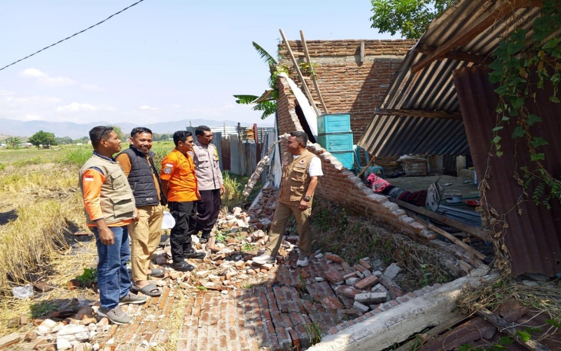
Indonesia's Flores Island experienced a catastrophic natural disaster in the early hours of Saturday when a magnitude 7.7 earthquake struck approximately 30 kilometres from Mbay at a depth of 15 kilometres beneath the seafloor. The tremor, which hit at 4:58 am local time, triggered immediate evacuations as authorities and residents alike scrambled to reach safety. According to the National Disaster Management Agency (BNPB), roughly 2,000 people were either formally evacuated by authorities or fled their homes independently following the violent shaking and the tsunami warning that was subsequently issued.
The earthquake's destructive force left a significant trail of damage across multiple districts in East Nusa Tenggara. Preliminary assessments conducted by disaster management officials revealed that 54 residential structures suffered severe damage, with an additional nine sustaining moderate harm and 11 experiencing minor damage. The impact extended beyond homes, affecting critical infrastructure including five health facilities, one educational institution, three places of worship, one warehouse operated by the state food logistics agency Bulog, and six government offices. The Manggarai district emerged as particularly hard hit, with 29 houses completely damaged, nine moderately affected, and nine sustaining lighter damage, while the neighbouring East Manggarai district reported 23 severely damaged residences.
The death toll from the disaster reached at least 20 people, with six others injured and two individuals still trapped in the aftermath of the main quake and subsequent powerful aftershocks. These casualty figures underscore the severity of the event and the challenges faced by first responders working in affected communities. The Maumere Search and Rescue Office coordinated emergency response efforts throughout the region, though full casualty assessments remained ongoing as teams continued searching through damaged areas.
One of the most concerning aspects of the earthquake's aftermath has been the extraordinary number of aftershocks recorded. The Meteorology, Climatology and Geophysics Agency (BMKG) documented 111 aftershocks following the initial tremor, a figure that speaks to the significant tectonic stress released during the event and the geological instability continuing to affect the region. The repeated shaking has hampered rescue and recovery operations while compounding the psychological trauma experienced by survivors already displaced by the primary earthquake.
The immediate tsunami threat prompted a precautionary warning that authorities disseminated widely throughout vulnerable coastal areas. However, the Meteorology, Climatology and Geophysics Agency lifted this warning at 7:31 am after monitoring stations detected no significant rise in sea levels beyond normal parameters. This decision, while providing relief to residents and allowing authorities to redirect focus to land-based emergency response, reflected the careful assessment of actual versus potential threats that characterised the disaster management response.
Communications infrastructure suffered extensive damage, creating additional complications for coordinated rescue and relief efforts. The Communication and Digital Affairs Ministry identified that 200 base transceiver station sites across 10 districts and cities in the province were experiencing service disruptions as of 7 am on the morning of the earthquake. These disrupted sites represented 16.35 per cent of all telecommunications infrastructure in the affected areas, significantly hampering the ability of residents to contact loved ones and coordinate assistance. The ministry's Digital Infrastructure director-general Wayan Toni Supriyanto confirmed that authorities were coordinating with mobile operators to restore these critical communication links as quickly as possible.
The comprehensive disaster response involved multiple layers of government and security apparatus working in concert. The national disaster management agency worked alongside regional disaster management bodies, military units, police forces, and local government administrations to assess damage, verify casualty figures, monitor ground conditions, and address the immediate needs of affected residents. This coordinated approach reflected established disaster response protocols while highlighting the complexity of managing emergency situations across remote island communities with limited initial infrastructure.
For Malaysian observers, the Flores earthquake serves as a sobering reminder of the significant seismic risk that characterises the wider Southeast Asian region. Indonesia sits along the Pacific Ring of Fire and the Alpide Belt, making it one of the world's most seismically active nations. The frequency and severity of earthquakes in Indonesia—and the cascading impacts on neighbouring regions through tsunami generation—underscores why sophisticated early warning systems, well-trained disaster response mechanisms, and coordinated regional cooperation remain essential priorities for maintaining public safety across the archipelago and broader Southeast Asia.
The ongoing assessment process remained incomplete even as initial reports circulated, with officials explicitly acknowledging that impact data was still being collected, verified, and validated across multiple affected zones. This methodical approach, while sometimes appearing slow to outsiders, reflects the necessity of obtaining accurate information before committing resources and formulating comprehensive recovery strategies. The eventual damage assessments would likely reveal impacts extending beyond the preliminary figures, particularly in areas with limited initial access or reporting capacity.

