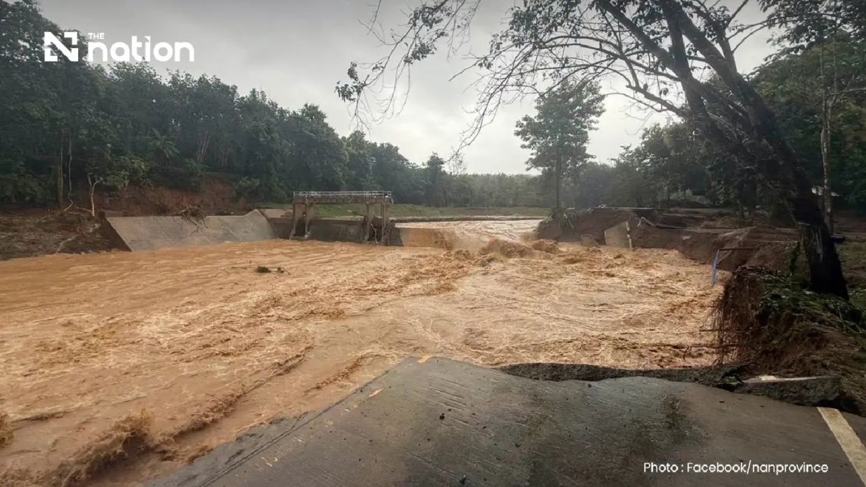
Flash flooding struck Pua district in Nan province across northern Thailand in the early hours of Wednesday, August 19, after torrential rainfall overnight triggered widespread damage to residential areas, agricultural land and critical transport routes. The Doi Phu Kha National Park recorded precipitation exceeding 110mm, creating dangerous conditions that forced rapid evacuations and left communities struggling to access basic services and emergency assistance.
The downpour was concentrated in Phu Kha subdistrict, a densely forested headwater region that typically channels water quickly toward lower elevations. Meteorological reports indicated the heavy rain persisted throughout the night, with officials receiving initial damage assessments around 6am as the full extent of the flooding became apparent. The combination of steep terrain and saturated ground conditions in the national park area created ideal circumstances for rapid runoff, transforming streams and tributaries into destructive torrents that overwhelmed local drainage infrastructure.
Residents across multiple communities had minimal warning before floodwaters surged into their homes and surrounding agricultural plots. Many families lacked sufficient time to salvage belongings, household appliances and family pets before water inundated their properties, resulting in substantial losses that will take months to recover from. The speed of the flooding—typical of flash flood events in mountainous terrain—meant that residents in lower-lying areas of Ban Rong and surrounding subdistricts had only minutes to seek safety on elevated ground.
Ban Na Lae, situated along the main route toward Doi Phu Kha National Park and Bo Kluea district, experienced particularly severe impacts when a critical bridge spanning a swollen waterway was completely washed away. The destruction rendered the thoroughfare impassable for all vehicle traffic, effectively isolating communities on either side and hampering emergency response efforts. The loss of this bridge represents a significant setback for regional connectivity, as it serves as a vital link for residents, commercial transport and agricultural produce movement between districts.
Geological instability accompanied the hydrological crisis, with multiple landslides reported across Ouan subdistrict as saturated hillsides gave way. These secondary hazards compounded response challenges by blocking additional roads and creating fresh obstacles for rescue teams attempting to reach isolated villages. The combination of flooding and landslides demonstrates the cascading nature of extreme weather events in Thailand's northern upland regions, where topography amplifies meteorological risks.
Another major bridge at the Fai Chao weir area also collapsed under the weight of floodwater and debris, further fragmenting transport networks in the affected zone. Nan Highway District 2, operating under the Department of Highways, conducted systematic surveys of road conditions and identified three critical locations where vehicular passage became impossible. Officials issued broad traffic warnings recommending that travellers completely avoid affected routes, a precaution that will disrupt commercial logistics and daily commuting patterns across the region.
The Thai government mobilised its disaster management apparatus in response to the crisis. The Department of Disaster Prevention and Mitigation coordinated with major mobile network operators—AIS, True and NT—to issue emergency Cell Broadcast alerts to all mobile devices within Pua district. The alert warned residents of continuing heavy rain, flash flood risks, waterway overflow and ongoing landslide danger, while explicitly instructing people to move valuables and vulnerable individuals to higher ground immediately.
Authorities emphasised the particular vulnerability of elderly residents and bedridden patients, populations that often face mobility challenges during rapid evacuation scenarios. The emergency message directed residents requiring assistance or evacuation to contact their subdistrict heads, village leaders and local administrative organisations, establishing clear chains of command for coordinating relief efforts. This communication strategy acknowledges the distributed nature of governance in rural Thailand, where village-level administration frequently serves as the primary interface between citizens and emergency services.
The Nan Provincial Disaster Prevention and Mitigation Office took operational control of response activities, releasing initial situation reports and pledging to provide updated information as conditions evolved. The office's involvement signals recognition at the provincial level that this represents a major incident requiring sustained monitoring and resource allocation. Subsequent flooding assessments would determine whether the situation warranted declaration of disaster zones or activation of provincial-level emergency protocols.
The Northern Meteorological Centre of the Thai Meteorological Department provided technical analysis indicating that weather radar systems detected precipitation bands spanning nine provinces across Thailand's upper northern region. These rain formations were tracking south-westward, suggesting the possibility of additional rainfall affecting districts beyond Pua in coming hours. This trajectory posed serious concerns for downstream communities in lower-lying areas, where rivers and streams would carry accumulated floodwater from higher elevations.
The flooding in Pua reflects broader patterns of climate-related hazards increasingly affecting Southeast Asia, particularly in upland and mountainous zones where topography amplifies precipitation impacts. For Malaysia and other regional neighbours, the incident underscores the transnational nature of hydrological risks and the importance of coordinated weather monitoring and disaster preparedness across shared river basins and weather systems. Thailand's experience demonstrates both the destructive capacity of concentrated rainfall events and the critical role of rapid communication systems in enabling timely evacuation and emergency response in remote communities.
The disaster also highlights vulnerabilities in rural infrastructure, particularly bridges and road networks that often lack adequate capacity to withstand extreme hydrological events. Rehabilitation and reconstruction efforts will likely extend over months, affecting regional trade patterns and community access to markets and services. Understanding these vulnerabilities informs resilience-building efforts across Southeast Asia, where similar terrain-related flooding risks affect numerous communities from Myanmar to Vietnam.

