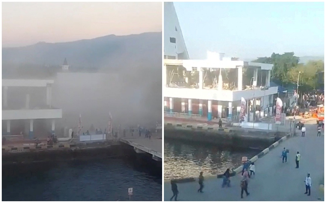
A devastating magnitude 7.7 earthquake that struck off the coast of Flores Island in eastern Indonesia early Saturday has claimed 20 lives, according to emergency officials. The Maumere Search and Rescue Office reported that alongside the fatalities, six people sustained injuries while two others remained trapped beneath debris. The powerful temblor, which originated near Mbay town in Nagekeo Regency, unleashed several powerful aftershocks across the region, adding to the sense of unease among residents already grappling with the initial disaster.
The earthquake's immediate aftermath revealed widespread structural damage across affected communities in East Nusa Tenggara province. Social media footage captured the moment buildings crumbled into dust as terrified residents fled into streets seeking safety. Governor Melki Laka Lena of East Nusa Tenggara acknowledged that numerous residential structures and public buildings sustained significant harm, whilst critical infrastructure including roads was either severed or rendered impassable by cascading landslides triggered by the quake's force. However, provincial authorities emphasised that comprehensive damage assessments were still underway, suggesting the full scale of destruction remained uncertain.
The disaster's reach extended to broader regional operations, as multiple flights serving East Nusa Tenggara province were cancelled in the immediate aftermath, disrupting travel and potentially hampering rescue and relief efforts. The cancellations reflected both safety concerns about continued seismic activity and the practical challenges of operating in affected areas where infrastructure damage has complicated normal operations. This transportation disruption could complicate the delivery of emergency supplies and medical assistance to the most severely impacted locations.
Initial responses from regional authorities demonstrated the international dimension of such crises. The Chinese Consulate General in Denpasar issued formal advisories to Chinese nationals within its consular jurisdiction on Saturday morning, specifically targeting tourists concentrated in Labuan Bajo. The guidance encouraged visitors to exercise heightened caution and monitor official disaster bulletins continuously. Consular officials explicitly warned citizens against approaching coastal zones due to lingering tsunami hazards, whilst advising comprehensive preparation for potential subsequent seismic events that commonly follow major earthquakes.
The geological mechanism behind the disaster revealed itself gradually as authorities gathered information. Indonesia's Meteorology, Climatology and Geophysics Agency initially issued tsunami warnings in response to the powerful offshore earthquake, but subsequently determined that a significant tidal wave would not materialise, leading to the cancellation of maritime hazard alerts. Nevertheless, the agency maintained its insistence that residents remain vigilant against ongoing aftershock activity, recognising that earthquakes of this magnitude invariably generate secondary tremors that can cause additional casualties and structural failure in already-weakened buildings.
The earthquake underscores the persistent seismic vulnerability that characterises eastern Indonesia's geographical position along the Pacific Ring of Fire, one of the world's most tectonically active zones. The region experiences frequent seismic disturbances due to complex interactions between multiple tectonic plates, making earthquakes an endemic hazard rather than a rare occurrence. For Malaysian readers, the disaster serves as a sobering reminder of shared regional exposure to natural hazards, as Southeast Asia sits atop several major plate boundaries where major earthquakes remain an existential threat despite advances in monitoring and prediction capabilities.
Search and rescue operations continued to unfold across affected areas as emergency teams methodically worked to locate trapped individuals and provide critical medical attention to the injured. The ongoing nature of these operations reflected the challenging terrain and damaged infrastructure that characterised much of the earthquake zone, where difficult conditions slowed rescue efforts and complicated the transport of casualties to medical facilities. Each passing hour increased risks for those still buried beneath collapsed structures, creating mounting urgency for coordinated rescue operations across multiple sites.
The provincial administration faced considerable challenges in marshalling an effective disaster response amid ongoing seismic activity. Authorities acknowledged that compiling comprehensive casualty figures and damage inventories remained an incomplete task, suggesting that final death tolls and property loss calculations could rise significantly once assessments concluded. This data-gathering difficulty reflects the typical chaos that characterises disaster zones immediately following major seismic events, where communication networks often fail, access routes become impassable, and survivors remain in shock.
For regional observers, the earthquake highlighted the critical importance of maintaining robust disaster preparedness systems throughout Southeast Asia. Indonesia's established protocols for tsunami warnings and aftershock monitoring demonstrated institutional capacity to respond to geological emergencies, yet the persistence of significant casualties nonetheless illustrates the limits of engineering and planning against nature's raw power. Malaysian authorities and disaster management agencies can derive lessons from Indonesia's response patterns regarding evacuation coordination, rescue logistics, and international communication protocols during cross-border humanitarian emergencies that increasingly characterise the region.

