Two signalised intersections on Jalan Ampang—one fronting the Royal Thai Embassy and another at Lorong Ampang 2—have been permanently closed from today as Kuala Lumpur City Hall (DBKL) progresses with an extensive upgrade programme designed to modernise one of the capital's busier thoroughfares. The closure marks a significant intervention in urban traffic management, reflecting a broader shift towards eliminating junction conflicts in favour of streamlined arterial road design.
The 3.2-kilometre upgrade initiative extends from the Jalan Tun Razak intersection southeastward to Middle Ring Road 2 (MRR2), encompassing a stretch that has long functioned as a critical connector between the city centre and eastern residential suburbs including Ampang. By removing traditional traffic lights at specific points, planners aim to reduce the frequency of stop-and-go driving and the congestion patterns that accumulate at such junctions during peak commuting hours.
DBKL's statement emphasises that the project's core objective centres on three interconnected goals: enhancing overall network efficiency, bolstering user safety through better infrastructure design, and ensuring uninterrupted traffic progression along this major corridor. The authority recognises that sustained congestion undermines economic productivity for businesses in surrounding areas and diminishes air quality across the residential neighbourhoods that border Jalan Ampang.
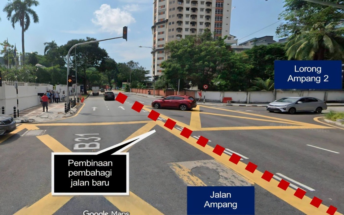
The physical transformation will be comprehensive. Road dividers will partition opposing traffic flows, eliminating dangerous crossing movements and reducing weaving conflicts that typically occur when vehicles attempt uncoordinated lane changes. The upgrade specifies a two-way four-lane configuration—likely two lanes in each direction—providing greater capacity than the existing layout while maintaining a disciplined traffic structure. Safety for pedestrians will improve markedly through the construction of wider, better-maintained walkways equipped with improved street lighting, a feature particularly important given the area's mix of commercial establishments, embassies, and residential zones where foot traffic remains significant throughout the day.
The removal of traffic signals at two intersections represents a calculated trade-off in urban design philosophy. Rather than accommodating all turning movements at individual junctions, the new scheme directs drivers towards designated U-turn facilities positioned strategically along the corridor. This approach, increasingly common in Southeast Asian cities managing rapid motorisation, shifts control from intersection-by-intersection management to corridor-level flow optimisation. The primary advantage lies in reduced intersection dwell time and fewer collision points, though it requires drivers to accept longer path distances for certain turning manoeuvres.
To mitigate disruption during the transition, DBKL has designated alternative routing protocols. Vehicles intending to access Ampang from the city centre now have the option of executing a U-turn at Jalan Tun Razak, while those heading towards the city from Ampang can reverse direction at Jalan Ampang Hilir. These designated turning points will presumably feature either traffic signals or roundabout designs capable of safely handling concentrated turning volumes during peak periods. The success of this mitigation strategy depends heavily on driver familiarity with new routing and compliance with directional signage.
For Malaysian commuters and businesses operating in the Ampang corridor, the closure initiates a period of adjustment that will likely persist throughout the project's construction phase. Delivery logistics, particularly for commercial establishments along Jalan Ampang, will require route recalculation and potentially longer journey times until the upgraded configuration is fully operational. However, the long-term efficiency gains anticipated by DBKL could ultimately benefit commercial operators through more predictable travel times and reduced fuel consumption during commutes.
The upgrade programme reflects DBKL's broader infrastructure strategy in addressing congestion within the Federal Territory, where road networks designed decades ago struggle to accommodate contemporary traffic volumes. Jalan Ampang specifically serves not only residential access but also connects several commercial nodes and international institutions, making it a critical component of Kuala Lumpur's overall mobility system. The intervention acknowledges that conventional intersection management approaches, while equitable in distributing access opportunities, often prove inefficient when handling high-volume traffic flows.
From a regional perspective, Malaysia's major cities are increasingly adopting grade-separated or streamlined corridor designs similar to this Jalan Ampang project. Penang, Johor Bahru, and other metropolitan areas have implemented comparable initiatives, indicating a nationwide trend towards prioritising throughput efficiency over intersection accessibility. This shift generates ongoing debate among urban planners regarding the balance between maximising vehicle movement capacity and preserving equitable access for all road users, particularly those in residential areas adjacent to upgraded corridors.
Public communication will be essential throughout this transition. DBKL has advised road users to strictly observe newly installed traffic signage and directional markings, emphasising that compliance reduces both personal inconvenience and system-wide congestion. The authority's announcement suggests that proper communication infrastructure—clear signage, public awareness campaigns, and perhaps digital navigation updates—will be critical to ensuring drivers adapt to the new routing patterns without excessive confusion during the initial weeks following closure.